Bloomington, Richfield, Edina, Eden Prairie in Hennepin County
First construction project has begun!
The first of four construction projects that are part of the I-494: Airport to Hwy 169 vision began in spring 2023. Work will be done on I-494 between E. Bush Lake Rd. in Edina and 12th Ave. N. in Richfield through fall 2026. For more information, visit the I-494 Edina to Richfield project webpage.
The I-494 vision is a long-term plan that includes improvements to address current and future transportation issues on I-494 from Hwy 169 to the Minneapolis-St. Paul Airport (MSP Airport). It is a major construction project that cannot be built all at once due to funding limitations and impacts during construction. As a result, four separate construction projects have been planned to complete the entire I-494 vision.
The first construction project, expected to start in 2023, will extend from East Bush Lake Rd. in Edina to 12th Ave. in Richfield.
We are using public feedback to design the aesthetic features and street amenities included in the I-494 vision. This includes ground colors and materials, medians, fences and railings, wall patterns, landscaping, lighting and more.
Summary of work
Provide a transit advantage to increase the number of people who can be efficiently moved through the area
Improve the reliability of the average rush-hour trip
Improve safety
Restore pavement to preserve infrastructure and provide a smoother ride
Improve drainage systems to reduce localized flooding and reduce run-off into the Minnesota River
Preserve existing bridges
Improve intersections to meet accessibility guidelines
Improve the pedestrian and bicycle network
Future improvements
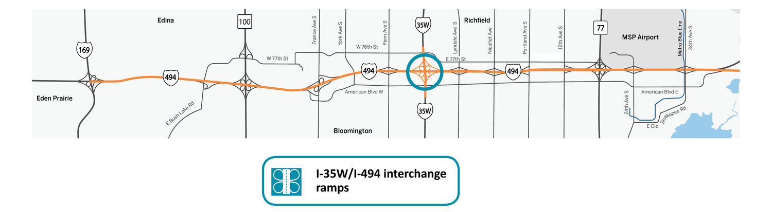
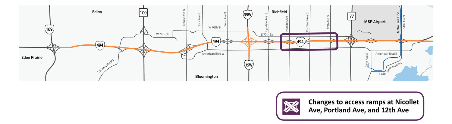
The goals for the I-494: Airport to Hwy 169 corridor is to reduce traffic congestion and improve safety on the highway. The corridor is divided into 3 focus areas: 1) I-494 mainline, 2) I-35W and I-494 interchange, and 3) changes to highway access at Nicollet Ave., Portland Ave., and 12th Ave.
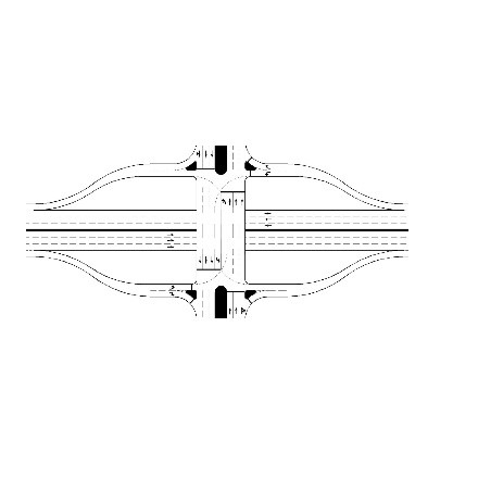
To best address current and future conditions for I-494, E-ZPass lanes were selected because they provided the best opportunity to address the needs in the selection criteria. A E-ZPass lane in each direction will add capacity to the interstate from Hwy 169 to Hwy 77. E-ZPass lanes could be used by all users during most hours of the day, and by buses and vehicles with 2 or more occupants during peak rush hour.
The image above shows the approximate lane configuration. Design details are under development and some dimensions may change. The new design retains the existing through lanes on I-494 and adds capacity with a new E-ZPass lane in each direction.
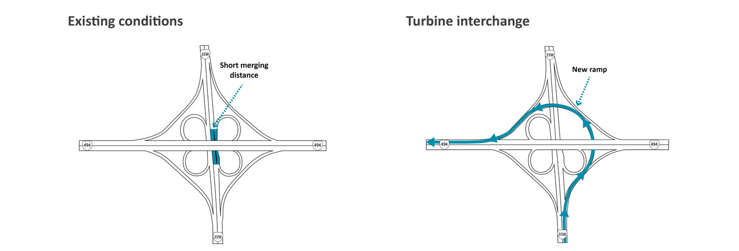
A turbine interchange will be constructed to address the goals of the study, including improved traffic operations and safety on both I-35W and I-494. The new ramp in the northeast corner of the interchange will allow traffic heading northbound I-35W to WB I-494 to flow more efficiently.
Existing entrance and exit ramps at Lyndale Ave., Nicollet Ave., Portland Ave. and 12th Ave. are too close, which causes congestion and safety issues on I-494. To reduce congestion and improve safety on I-494, MnDOT will:
Close all ramps at Nicollet Ave. and 12th Ave.
Create a full-access interchange at Portland Ave. with two on ramps and two off ramps
These improvements will provide adequate space for vehicles to safely enter and exit the interstate while upgrading all three bridges to better serve local pedestrians, bicyclists, and drivers.
Initially five interchange options were identified for Portland Avenue. After evaluating each interchange option, the team determined a tight diamond interchange design would best manage traffic operations and address safety concerns on the local road network and the interstate.
The I-494 vision has been separated into nine elements that will likely be completed in a series of four construction projects.
Element 1: A new westbound E-ZPass lane (from Hwy 100 to Hwy 169)
Element 2: A new eastbound E-ZPass lane (from Hwy 169 to Hwy 100)
Element 3: A new ramp at the I-35W/I-494 interchange and westbound E-ZPass lane (from I-35W to Hwy 100)
Element 4: A new eastbound E-ZPass lane (from Hwy 100 to I-35W)
Element 5: 82nd St. interchange and grade changes at I-35W
Element 6: New railroad bridge
Element 7: Changes to access and construction of new bridges at Nicollet Ave., Portland Ave., and 12th Ave., as well as a new pedestrian bridge across I-494.
Element 8: A new westbound E-ZPass lane (from Hwy 77 to I-35W)
Element 9: A new eastbound E-ZPass lane (from I-35W to Hwy 77)
How we decided what elements are constructed first
The team and its partners prioritized elements of the vision based on many factors. These factors reflect the concerns heard from the public at the beginning of this process.
The following criteria were used to decide what elements are included in each construction project and which project will be built first:
Constructability: evaluates how each element will operate with other elements being constructed at the same time
Community support: considers the top transportation priorities and needs for local communities
Equity: considers fair distribution of transportation options and investments for underrepresented communities
Asset management: considers the life cycle of other infrastructure, including new construction, maintenance, and reconstruction
Cost and funding: considers the cost of each individual element and the available funding
Operations and safety: evaluates how each element will impact the existing network and whether it improves current conditions, such as traffic congestion and safety
Based on these criteria, the following sequence will be used to complete the I-494 vision:
Project 1 will include elements 3, 4, and 7
Project 2 will include element 6
Project 3 will include elements 8 and 9
Project 4 will include elements 1, 2, and 5
The first construction project includes the elements that ranked the highest under the scoring criteria of the Implementation Plan. The first construction project includes elements 3, 4, and 7.
Elements 3 and 4
Elements 3 and 4 include the construction of an E-ZPass from Hwy 100 to I-35W in each direction.
A new ramp at the I-35W and I-494 interchange will also be constructed as part of the first construction project. These improvements will begin to address traffic congestion on I-494 and I-35W.
Element 7
Element 7 will remove I-494 access at Nicollet and 12th Ave. It will also expand capacity at Portland Ave. and provide full highway access to the interstate. New bridges over I-494 will be constructed at these three roads to accommodate future levels of traffic, improve pedestrian and bicycle mobility across the interstate, and meet accessibility guidelines for all users.
Improved facilities for pedestrians, bicyclists, and transit users are planned as part of the design at these locations. Improvements include wider sidewalks, designated bicycle lanes, and upgrades to some transit stations. New facilities will meet Americans with Disabilities Act (ADA) guidelines.
Element 7 also includes the construction of a new pedestrian bridge at Chicago Ave. to provide additional pedestrian and bicycle connections across I-494.
MnDOT is designing the aesthetic features and street amenities included in the I-494 vision. This includes wall texture, railings, landscaping, bridge pier design, decorative lighting and more. We also will identify locations for communities to incorporate public art into aesthetic features.
We heard hundreds of words and phrases that describe the character of your communities. There following were the top themes we heard:
Clear sky, green spaces, and blue water: access to nature and trails in the community
People make the place: community character and diversity
Connections, Connectivity, and Connecting: convenience of being connected to public services, employment, shopping, community spaces, and other local amenities
These themes inspired a series of design concepts that could be incorporated throughout the I-494 corridor. ‘Lake beds’ was the preferred design by the public and reflects characteristics unique to the local community and Minnesota.
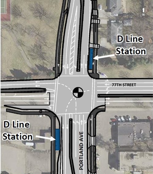
The METRO D Line will replace Route 5 with faster, more frequent, and all-day service. This 18-mile line will connect neighborhoods and destinations in Brooklyn Center, Minneapolis, Richfield, and Bloomington. Bus rapid transit is a package of transit enhancements that adds up to a faster trip and an improved experience. Learn more about D Line BRT project.
The first construction project will fully rebuild the intersection of Portland Ave. and 77th St. and will impact the D Line station at that intersection. Because construction is planned at this intersection in the future, temporary stations are currently being constructed on the northwest and northeast corners of intersection. Temporary stations will provide service when the D Line opens in late 2022. View the plans for temporary stations.
While construction is underway for the first construction project, expect detours for transit service near Portland Ave. and 77th St.
More information on transit detours will be communicated as construction plans are developed.
Permanent stations will be constructed in the southwest and northeast corners once the first construction project is completed (As shown in the image).